2000 to 2005 Forest Development Plan for W1832
The first proposed Forest Development Plan for W1832 was released for public review and comment on April 29, 2002. The Plan was revised to address comments received, and approved by the Ministry of Forests on September 28, 2002.
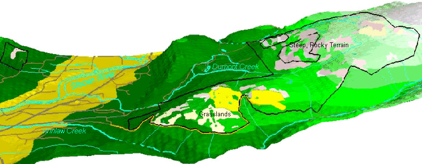
The Forest Development Plan shows the location of proposed logging and road access development for the first
five years of activities in W1832. (Note that the five year period started on January 1, 2000.) The FDP proposes:
- 27.5 hectares of partial cutting timber harvesting,
- 3.9 km of access road upgrading, and
- 300 meters of new road construction
within the Winlaw Creek and Dumont Creek watersheds.
Proposed harvesting is shown in bright yellow in the image below. The proposed road upgrading is shown in orange, and runs along the boundary of the woodlot.
The Forest Development Plan also includes information on the nature of and protection of other
resource values in the area affected by the proposed developments. The proposed management approaches to water supplies and watersheds, riparian ecosystems, wildlife and biological diversity, and visual management are explained.
The FDP explains the location and type of timber harvesting proposed, and the location and type of access development.
The proposed Silica Mine Road upgrade is discussed and described.
The approved 2000 to 2005 Forest Development Plan for W1832 is available for download in Acrobat 4.0 format below. The FDP can be accessed as a single large file, or as a set of smaller "section" files. The FDP maps and Appendixes are also posted on this site.
|
|
|
 Complete FDP:
|
|
Complete Approved 2000 - 2005 Forest Development Plan #1 for W1832 (3.5 mb PDF File)
|

|
|
|
Complete Appendixes (Except Appendix 6, which is available separately below.) (4.5 mb PDF File)
FPD #1 Map in GIF format (1.4 mb GIF File)
|
|
|
May 2005 Major Ammendment to FDP 1
|
|
May 2005 Major Ammendment to FDP #1
|
|
|
|
FDP #1 by section:
1. Introduction
Summary of proposed development activity, description of W1832, referral summary (0.7 mb PDF File)
2. Strategic Plans
(0.1 mb PDF File)
3. Sources of Information
Base mapping, forest cover mapping, streams and wetlands, known items identified by MOF and MELP (0.02 mb PDF File)
4. Measures to Protect Forest Ecosystems and Resources
Timber insects and diseases, water, watershed assessments, flat over steep terrain, riparian ecosystem management,
wildlife and biological diversity,recreation, visual resource management, cultural heritage resources and archaeological sites (2.5 mb PDF File)
5. Proposed Logging
Cutblock information, logging method, minor salvage operations, minor harvesting operations (0.2 mb PDF File)
6. Access Management
Road construction, road maintenance (0.2 mb PDF File)
7. Referrals Process and Summary of Ammendments in Response to Comments
(0.5 mb PDF File)
8. FDP Map
(1.4 mb GIF File)
|
|
|
Individual Appendixes:
Appendix 1: Full Cycle Trees
(0.01 mb PDF File)
Appendix 2: Correlation between mapped Point of Diversion Codes and Water Licencee Names
(0.016 mb PDF File)
Appendix 3: Interior Watershed Assessment Procedure: Results for Sub-Basins in W1832
for which Development is Proposed
(2.6 mb PDF File)
Appendix 4: Detailed Drainage Plan and Terrain Stability Assessment: Proposed Silica Mine Forest Road
(1.3 mb PDF File)
Appendix 5: Excerpts from the Forest Practices Code Riparian Management Area Guidebook
(0.6 mb PDF File)
Appendix 6: Archeological Overview Assessment and Archeological Impact Assessment
(7.7 mb PDF File. File is very large because it is a scanned image of archeology report. )
|
|
Home
|